ArcMap is a useful tool for constructing maps from geographic datasets. Once you have prepared a map in ArcMap, you need to save it in a format that allows it to be used in other applications (eg Word, Adobe Illustrator etc).
You might be tempted to use the "Save As..." option under the File menu. This brings up a dialog box that asks you to name the file, and specify whether you want it to be saved as an ArcMap document (.mxd) or an ArcMap template (.mxt).
Neither of these formats is suitable for use in any other application; they are ArcMap's native file formats, and only of use to ArcMap. They contain instructions that ArcMap uses to locate the datasets on your computer, and then reconstruct your maps. Even if you try opening these files in ArcMap on another computer, they will probably fail to work correctly, as the base data from which the maps are constructed will not be on that other computer.
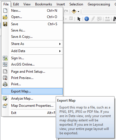
To export a map in a form that can be used in other applications, you need to select "Export Map..." from the File menu.
The Export Map dialog box will appear, asking you to specify the location where the file should be saved, and the filename that Arc Map should use. You are also offered a list of file formats in the "Save as type:" field. These options are:
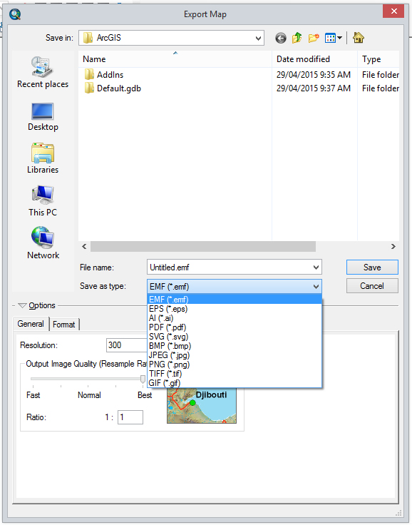
- EMF (*.emf)
- EPS (*.eps)
- AI (*.ai)
- PDF (*.pdf)
- SVG (*.svg)
- BMP (*.bmp)
- JPEG (*.jpg
- PNG (*.png)
- TIFF (*.tif)
- GIF (*.gif)
Options 6 through 10 create raster images (also known as bit maps); they cannot be resized easily, and look pretty bad if you do resize them. You should avoid these formats unless you are trying to create images for use on web sites, in which case you should use the JPEG or GIF formats.
Options 1 through 5 are vector formats. Vector formats contain drawing instructions that describe how to draw the map. Images in vector formats can be resized easily without any loss of detail.
EMF format
EMF (Enhanced MetaFile) is Microsoft's vector file format. EMF files can be imported directly into Microsoft Word on a Windows computer.

When exporting a map to an EMF file, click on the "Format" tab and make sure that the "Convert Marker Symbols to Polygons" box is ticked. This ensures that ArcMap exports north arrows and other cartographic symbols in a useable form.
EPS format
EPS (Encapsulated PostScript) is a vector format invented by Adobe for use in laser printers. It is also widely used in the publishing industry. EPS files can be imported directly into Microsoft Word on both Windows and Macintosh computers.
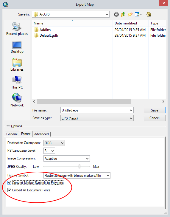
When exporting a map to an EPS file, click on the "Format" tab, and make sure that the "Convert Marker Symbols to Polygons" and "Embed All Document Fonts" boxes are ticked. This ensures that ArcMap exports north arrows and other cartographic symbols in a useable form.
AI format
AI (Adobe Illustrator) is the native file format for the Adobe Illustrator drawing package. This is the format you should use if you want to use Adobe Illustrator to add annotations to the map.
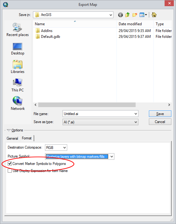
When exporting a map to an AI file, click on the "Format" tab, and make sure that the "Convert Marker Symbols to Polygons" box is ticked. This ensures that ArcMap exports north arrows and other cartographic symbols in a useable form.
PDF format
PDF (Portable Document Format) is the native file format for Adobe Reader.
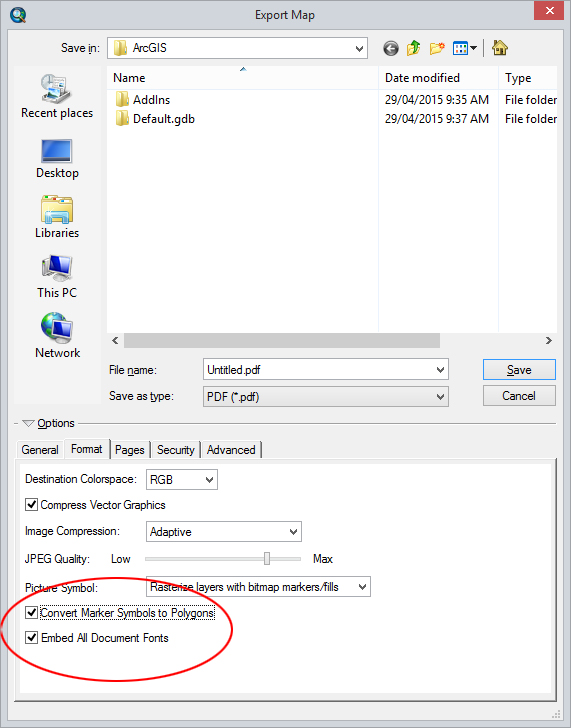
When exporting a map to a PDF file, click on the "Format" tab, and make sure that the "Convert Marker Symbols to Polygons" and "Embed All Document Fonts" boxes are ticked. This ensures that ArcMap exports north arrows and other cartographic symbols in a useable form.
SVG format
SVG (Scaleable Vector Graphics) format is a vector format that is starting to come into use on the Word Wide Web. Most modern web browsers support displaying SVG, however support for all features is not consistent between browsers. In future, it will be a good format for displaying maps on the web. SVG is also the native file format for the freeware Inkscape drawing package.

When exporting a map to a SVG file, click on t the "Format" tab, and make sure that the "Convert Marker Symbols to Polygons" and "Embed All Document Fonts" boxes are ticked. This ensures that ArcMap exports north arrows and other cartographic symbols in a useable form.


 menu
menu


